


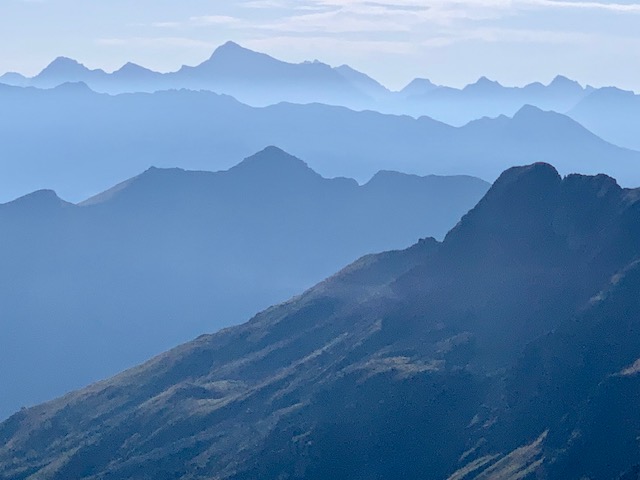
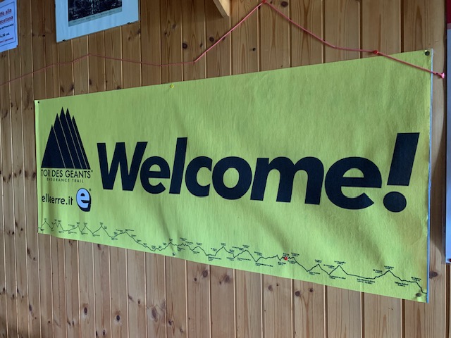
The AV1 and AV2 in Aosta Valley form part of a very long and stunning high-level hiking tour known as the Tor des Géants (TDG) because they passes under the shadow of those alpine giants Monte Bianco, Monte Rosa, Gran Paradiso and Monte Cervino (we’re walking on the Italian side so it feels like we should use their Italian names!).
The full tour is around 330km and starts and finishes in Courmayeur, taking around 3-4 weeks. Most people tend to hike a section at a time. Part one is known as AV2 and wanders cuts across the side valleys on the southern side of the Aosta valley, including through Gran Paradiso National Park, before turning back around Donnas with the northern flank now called the AV1.
We only had a week so started part-way into the AV1 route in Valtournenche which is accessible by rail and bus, which meant we effectively hiked from the Matterhorn (Cervino) back to Mont Blanc. As you might gather from that itinerary – it’s beautiful and lumpy!
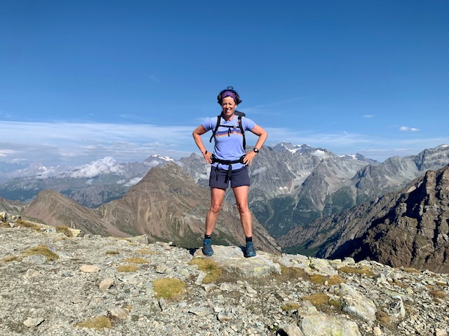
The route is not well known outside of Italy – I don’t think we met anyone on the trail who wasn’t Italian and it’s far, far wilder, a bit tougher and a lot less busy than its close neighbour the Tour of Mont Blanc (TMB). Inexplicably, as we reflected many times during the week, the full 330km route is probably better known international ultra running race with competitors taking 4-7 days to complete the route. It’s a beautiful route, but I didn’t ever think I’d rather be running it at any point! I walked with my old friend Marianne with whom I’ve now done an annual ‘hut tour’ for 11 consecutive summers.
We used a Ciccerone guidebook and the 4 local maps it recommended which I had to order from Italy in advance, but we discovered there’s a much cheaper map that covers the whole route which all the huts seem to sell and looks like a much better option.
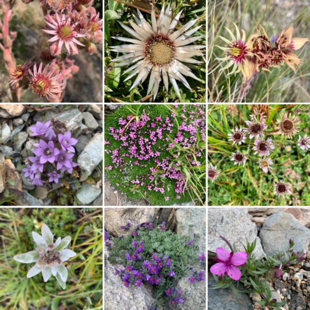
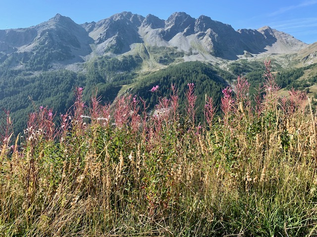
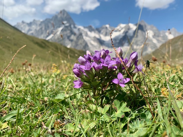
Even in mid August there were still a lot of flowers in bloom (and a huge variety of species – eyebright, edelweiss, black vanilla orchids, various gentians, pasque flowers, houseleeks etc) – and the wildlife was very good – we saw a fox, eagles, ibex, chamois.
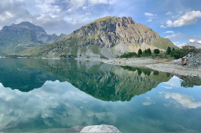
Day 1 we set off early from Chamonix to catch a bus through the Mont Blanc tunnel to the Roman town of Aosta, connecting to a train and then a bus which climbed into Valtournenche in time for lunch. It was a very, very hot day and the climb up to our first stop for the night the lakeside Rifugio Barmasse was short (about 2hrs but all up hill) and very sweaty!
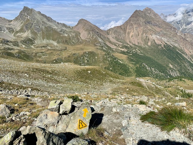
Day 2 was our first full day and fairly typical of a stage on TDG – about 17km with 1500m of climbing, over a series of cols between 2500-3000m. Route-finding was fairly simple – the race means there’s plenty of painted TDG yellow splashes on rocks or yellow triangular 1 symbols and the paths were easy to follow.
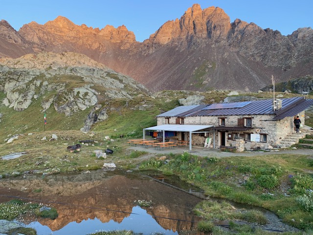
Day two ended at a high, basic and lonely hut - Rifugio Cuney - set beneath towering cliffs of a remote and impressive cirque. Run by a family, the hut was so small the guests had to sit outside until dinner time but I got to watch a herd of around 20 ibex feeding so that was no hardship! We’d been carrying micro-spikes as my guidebook warned about patches of nevé on steep/ exposed sections, but they stayed in the bags as we saw no snow patches. Overnight there was a tremendous storm with heavy rain and thunder and lightning. Glad to be safe inside the hut we marvelled at the power of the storm – but thought nothing more about it until we reached the valley the following day where we discovered it had caused a major landslip.
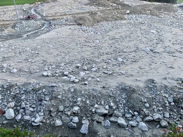
Day three – sleeping in a dorm I was up by 5:30am and rewarded with a stunning sunrise before setting off for another day rolling over various cols before a knee-crunching 1800m descent down to the valley floor and the village of Oyace. As we emerged from the forest into the village we were surprised to find the fields were flooded, and the road was covered in mud – the streams had clearly burst their banks last night.
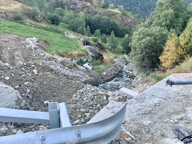
Walking up the valley to our hotel we were stopped by a local who explained the road was closed due to a landslip and he kindly showed us a path through the forest that avoided the road block. We saw a wrecked car that had been swept off the road into a river bed and the clean-up operation was extensive – there were diggers and tractors removing tonnes of silt and mud from the villages. These extreme weather events are becoming more common in Aosta valley (and the wider Alps) – and although we’d chosen to travel from the UK by train (rather than fly) conscious to minimise our carbon footprint – it was still shocking to see the damage caused by the landslip.
Grateful to be in the valley and not have to eat polenta for dinner yet again (and to have a chance to wash our stinky kit) we stocked up on local cheese for the next day’s walk which involved yet another major col.
Up, up, up and then down, down, down was becoming the pattern of the days. The trails were so quiet – we barely saw another hiker all day – there were some other groups doing the same trail as us but we’d usually set off before them and only see them at the rifugio later. The paths were gloriously quiet as if we had the hills to ourselves.
Day 5 ended in Olloment – a tiny village. There are very few places to stay or eat along the trail, so we were glad to have booked ahead – most places only had one option. We also ended up carrying quite a bit of food as there was nowhere en route to get lunch (the huts are spaced too far apart and there are no shops except in the villages at the start/end of the day).
The forecast for the following day was looking dodgy – with lightning forecast from mid morning onwards and a 2800m col to cross in the middle of the day with no escape options. I didn’t think that was wise, so we crafted an alternative route which took us up to around 2000m and then contoured through forests and closer to villages where we could shelter if the lightning materialised. We still got great views and we escaped the storm, although we could see lightning further down the valley and hear the thunder getting closer and closer, arriving at our next base St Rhemy just as the first drops of rain started to fall.
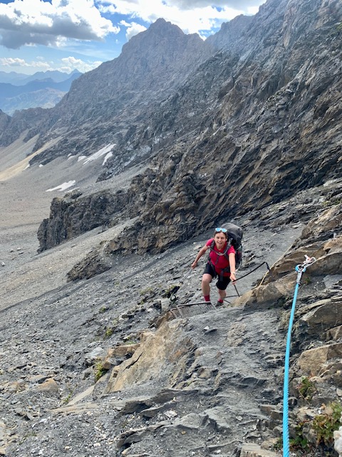
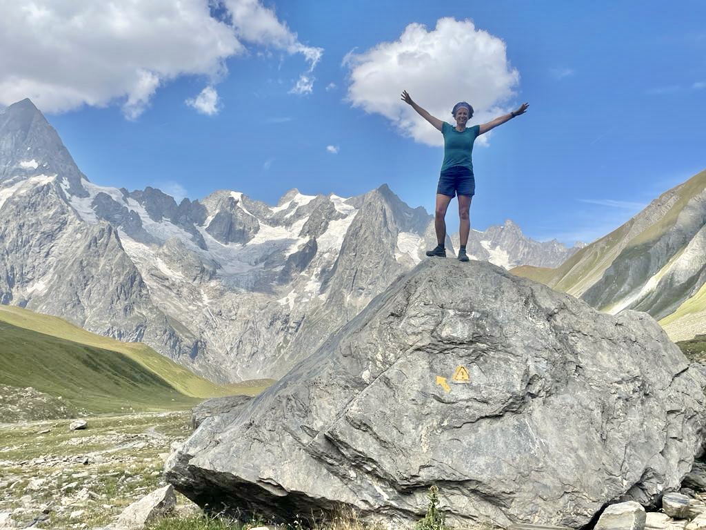
Day 6 was an absolute belter – a long but steady climb up to Col Malatra at just over 3000m, stopping at Rifugio Frassati a very friendly large hut where we ate lunch before setting off for the final big climb over the scree slopes to an interesting col which was more like a small notch in the ridgeline. Unnecessary fixed cables and iron work bolted to the rocks made it all look a lot more challenging than it was. I sometimes wonder how Italians would feel if they came to the Lake District and saw our lack of fixed cables.
The valley leading up to Col Malatra is stunning, but the views through the other side of the col were even better – and we descended with the Grandes Jorasses as constant companions. I took about a million photos of the flowers and the mountains!
Our final night in the hills was spent at the very busy but spectacularly situated Rifugio Bonatti and then early the following morning we wandered along the familiar TMB balcony path via Rifugio Bertone which must be one of the most scenic sections of balcony path in the alps and then dropping steeply into our end point Courmayeur for a well-earned gelato before catching the bus through the Mont Blanc tunnel back to Chamonix by lunchtime.
So I’d definitely recommend TDG – it’s on the harder end of hut-to-hut tours in terms of physical exertion (mainly the relentless ups and downs), but it’s not technical and the quietness and wildlife are excellent. We did struggle a bit with the language – we speak a little Italian but very few people spoke English and with all the other hikers being Italian it was a little harder than usual to join in conversations over dinner, although everyone was friendly. Due to being on the French-Italian border, in Aosta valley the locals seem to speak French as their second language so we were able to muddle through logistics in French. Finally a word about travel – we used Eurostar to get to Paris from London (2.5 hrs) then travelled by TGV to Geneva (just 3 hrs) from where we connected via Chamonix on the way out (I spent a week in Chamonix before heading to Italy). On the way home we caught buses back from Courmayeur-Chamonix-Geneva then stayed in a hotel by the station so we could catch an early train home from Geneva – so I was home to York by 6pm! It takes a bit of planning, and to get cheap tickets we needed to book ahead, but when train travel creates around 15 times less carbon than flying it feels worth the effort – especially when the signs of climate change are so evident in the alps these days.
Great report Claire, it must have taken an age to write. And some great pictures too – stunning scenery. Certainly one for the list of ‘things to do’!
Thanks for a very interesting Report of an attractive Tour